Плоттер SamYung NAVIS 3000
| ООО“ ЕвроСатТроник ” / Ltd. “ EuroSatTronic ”
|
FEATURES |
Supreme
brightness of 350 candela. |
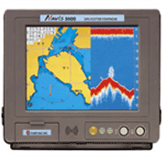
Adoption
of TFT LCD 10.4" color
display giving clear pictures
and wide view angle. |
Built
in high speed CPU and revert
display softly |
Course-up,
head-up, north-up, true-motion
function per 0.1 |
Having
2 C-MAP NT cartridge slot which
offer world map for ocean going
fishing
vessel. |
Pull-down
mode in manual and automatic
help menu for instruction. |
Double
key board which is made up of
front keyboard and remote controller. |
Best
safety from heat,seawater,shock |
Available
for new fishery communication
network. |
Worldwide
precise electronic chart provides
more exact reading and various
information
such as depth of water,lighthouse,mud,rocks,wrecks.EEZ,undersea
cable |
Actual
user can make & amend chart
in Korean, English, numbers
and signs
directly. |
Can
search minute shools of fish
strongly with dual frequency
transducer |
High
performance transducer |
Valve
automatic open-closed printing |
STANDARD (GPS RECEIVER) |
Receiving
frequency : L1 1575.42 MHz(C/A
CODE) |
Receiving
channel & tracking satellite
: 12 channel & 12 satellite |
Receiving
type : Digital 12channel multi
tracking type |
Receiving
sensitivity : -143dBm |
Accuracy
: GPS(NAVIS 3000)
a)
Position : 10M 2D RMS(HDOP<2)(SA
OFF)
DGPS(NAVIS
3000D)
a)
Position : 3M 2D RMS(HDOP<2)(SA
OFF)
b)
Velocity : 0.1kt RMS(HSOP<2)(SA
OFF) |
STANDARD(DGPS BEACON
RECEIVER) |
Receiving
frequency : 283.5~325.0KHz |
Modulation
: MSK(minimum shift keying) |
Bitrate
: 50,100,200bps |
STANDARD (PLOTTER) |
Display
: color VGA TFT LCD (10.4") |
Resolution
: 640 480 pixels 256 color |
Projection
: Mercator drawing |
Effective
range : below 85 of
latitude |
Scale
0.25 mile ~ 5,000 mile(1/2000~1/37,500,000) |
Tracking
memory interval : 1sec~60minute(0.01~9,99NM)
set-up |
Tracking
capacity : 20,000 points , work
log book (99 pages) |
Event
mark : 21 kinds
Mark
capacity : 10,000 points
capacity
for user's drawing of shoreline
: 8,000points 16 land coloring
capacity
for user's marking of shoreline
: 1,000point
capacity
for user's character of shoreline
: 1,000point
capacity
for tracking marking : 1,000point
capacity
for memory of destination :
1,000points
capacity
for memory of route : 20 routes
(20 points/1 route) |
Display
mode : normal, true-motion,
course-up, north-up, head-up
function |
Alarm
: 1)arriving alarm 2)off-course
alarm 3)anchor alarm 4)boundary
alarm |
Interface
: SAMYUNG, NMEA0183, FURUNO(CIF),
JRC |
Power
supply : DC 10V~40V, Power
Consumption : 40W |
STANDARD(FISHFINDER) |
Operating
frequency : 50/200KHz dual or
50Khz,200KHz one frequency |
Output
: 600KW(dual),1.5KW(one frequency) |
Display
color : 16colors |
Range
of depth : 5~1,500M(depth of
water,automatic output power
control) |
Range
of bottom(enlargement of tracing)
: 10,20,40,80M
(enlargement
of flatterned bottom) : 2.5,5,10,20,40,80M
(partial
enlargement) : 5,10,20,40,80M |
Shift
speed : OFF,1,2,3,4,5,6,7 |
Information
: depth ,schools of fish, water
temperature |
Display
of function : Sensitivity,attenuation,transmitting
output,time marking,
depth,variable
scales,color patterns |
GENERAL |
Interface
: SAMYUNG, NMEA0183, FURUNO(CIF),
JRC |
Power
supply : DC 10V~40V, Power
Consumption : 40W |
Basic
component |
NO. |
Description |
Model |
Q'ty |
Remarks |
1 |
(D)GPS LCD plotter |
NAVIS 2500/NAVIS 2500D |
1SET |
|
2 |
(D)GPS antenna |
SAN-250/DSAN-250 |
1SET |
|
3 |
Remote controller |
REM-3000 |
1SET |
|
4 |
Transducer |
|
1SET |
|
|
nstallation materials,
spare parts, manual |
|
1LOT |
|
Option
component |
No. |
Description |
Model |
Q'ty |
Remarks |
1 |
CC????/under
water camera |
|
1EA |
|
2 |
Weather fax receiver |
|
|
|
3 |
TV/FM video receiver |
|
|
|
4 |
Exclusive receiver
for weather fax |
|
|
|
5 |
C-MAP NT map |
|
|
|
6 |
Printer |
|
|
|
Нажмите Ctrl-D, чтобы добавить эту страницу в 'Избранное' или 'Закладки' |
По всем вопросам относительно цен (если Вы не нашли их на сайте) просьба
связаться с нами по указанным ниже адресам либо телефонам.
Интересы посредников учитываются. Звоните. |
| Контактная информация компании ЕвроСатТроник |
| Телефон/факс | (495) 743-78-34
(495) 743-78-04
Понедельник - суббота с 10.00 до 16.00, воскресение с 10.00 до 14.00 (по московскому времени) |
| E-mail |
office@eurosatt.com |
| Адрес | 125230 Москва, Варшавское шоссе, 42.
|
| 